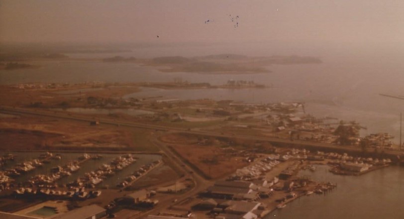
 Kent Narrows looking west
When I was selling Eastern Shore real estate in the early 1980’s, my friend, mentor, and broker Reggie Jones, kept a sales book featuring aerial views of various regional neighborhoods, subdivisions, and properties.
When I was writing my 2010 book, Remembering Kent Island: Stories from the Chesapeake, Reggie was one of my sources. Not only did Reggie share with me his knowledge and stories of the area, he gave me his book of aerial photographs. Reggie also told me that the pilot for these flights was Kent Islander Ace Allen.
The pictures below are from around Kent Narrows, the body of water that connects Eastern Bay and the Chester River, and Kent Island from the rest of the Eastern Shore.
******************
From Wiki: “The Kent Narrows, also known as Kent Island Narrows and to local residents simply as the Narrows, is a waterway that connects the Chester River with the Eastern Bay and also separates Kent Island from the Delmarva Peninsula. It runs through the community of Kent Narrows, Maryland. The area has traditionally been a location for seafood packing and restaurants.”
When Captain John Smith sailed the Chesapeake Bay in the 17th century, he named the vast unexplored marsh and woodlands east of what would become Kent Island Brooke’s Forest. The channel separating the island from the Eastern Shore mainland was at one time so narrow and shallow it was called the Wading Place.
In the colonial period, a small ferry crossed Kent Narrows. In 1820, Captain James Hopkins built the first causeway of “logs, stones, earth and shells” to connect Kent Island to the rest of the Shore. In 1902, the Queen Anne Railroad, which ran from Lewes, Delaware to Queenstown, extended its track 13 miles over Kent Narrows and north to Kent Island’s Love Point. Today, the six lane highway that opened in 1990 towers over the 1952 drawbridge that many of us grew up with.
The British army came ashore near Ferry Point on the northwestern side of the Narrows in the War of 1812. Hesitant to strike the cities of Annapolis and Baltimore, a force of up to two thousand men erected a battery at Kent Narrows and from that vantage point made forays onto the mainland. Suffering from fever and scurvy, the troops needed food badly, and they took advantage of the access to crops, game and livestock. On August 13, 1812, 1,500 British soldiers assembled in the early morning hours to make a surprise attack on Queenstown and Centreville. Barges full of men went up the river to assist. The boats got lost. Off-Island militia ambushed the troops marching along the way, surprising the Brits so badly several were shot by startled comrades. Recent studies indicate events did not transpire as locals have always told it, but the woods at the corner of Route 18 and Bennett’s Point Road where this bloody encounter was supposed to have taken place has been known as Slippery Hill for as long as anyone can remember.
Around the beginning of the 20th century, Charles Nash and his son moved their seafood packing house from another location to the northeastern Kent Narrows peninsula, where Pete Baxter had also started an oyster shucking business. Eventually there would be up to 14 packing houses, usually owned by entrepreneurial watermen, on that side of Kent Narrows and the area grew into one of the Eastern Shore’s economic hubs.
https://www.kentnarrowsmd.com/
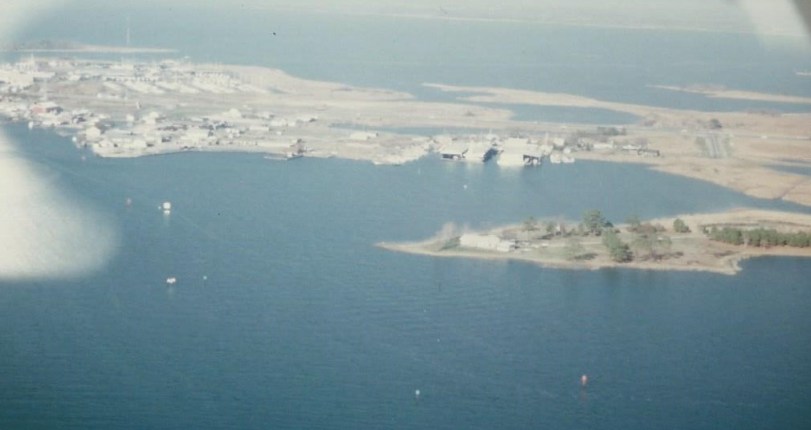
 Ferry Point / northwestern Kent Narrows
http://www.parksnrec.org/hiker-biker-trails/parks-and-maps/
From the Queen Anne’s County Recreation website:
Ferry Point Park is accessible from the Chesapeake Heritage and Visitor Center. The park is 41 acres of tidal wetlands, non-tidal wetlands and uplands. Rich in wildlife, one might expect to possibly see herons, ospreys, eagles, ducks, geese, swans, turtles, bullfrogs, and deer at Ferry Point. Surrounded by three bodies of water (Chester River, Kent Narrows and Piney Creek) the parks scenic views are magnificent. Ferry Point Park has approximately (1) mile of hiker / biker trails, picnic tables, sitting benches and interpretive signage. The park is a wonderful interpretive and passive recreation spot within the Kent Narrows.
Address: 425 Piney Narrows Road – Chester, MD 21619
Hours: Sunrise to Sunset
Directions: Rt. 50/301 exit 41 to Piney Narrows Road
Pets: Allowed on Leash
Fees: None
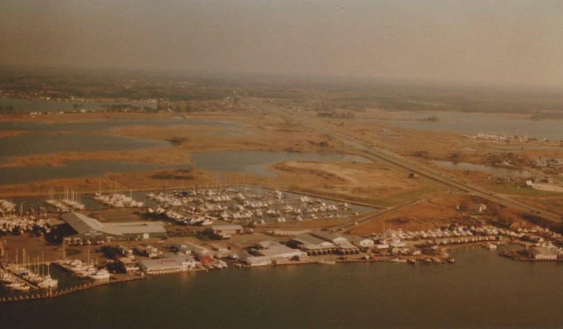
 Kent Narrows looking east
 Kent Narrows east
 Northeast Kent Narrows
 Kent Narrows east & Wells Cove 2017 Courtesy of Kent Narrows Development Foundation
https://www.kentnarrowsmd.com/

thank you what great memories. Reggie and Ace are name from our past.
Thanks, Doris! Glad you enjoyed! Merry Christmas to all the Donovans! Please say hi for me!
Wow! Things have really changed since then. Thank for sharing.
Thnak you for taking the time to comment! Hope you continue to enjoy easternshorebrent!
Excellent, Brent, Excellent.
Thanks, Helen! Merry Christmas to you and yours!
We are moving there in January. Love learning more and more about the area.
Awesome hope you like it here on the Eastern Shore (its a really nice place to live) , and hope you continue to check out easternshorebrent!